Unfun Map Games
I recently updated the Explore Shanghai app on my iPhone and was saddened to see this:
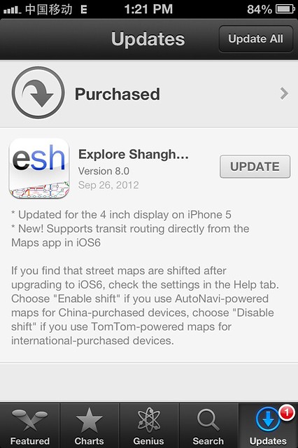
Take note of this part:
> If you find that street maps are shifted after upgrading to iOS6, check the settings in the Help tab. Choose “Enable shift” if you use AutoNavi-powered maps for China-purchased devices, choose “Disable shift” if you use TomTom-powered maps for international-purchased devices.
Huh? What’s going on here?
I’m no expert on this issue, but essentially, the Chinese government is paranoid about the use of GPS, and screws with it. This affects Google Maps, it affects camera GPS, and it even affects runners’ watches. It’s been going on for years. Chinese companies with government approval (like TomTom) can get their services/devices working properly, but foreign devices which try to rely on good old-fashioned “satellite positioning” and maps lose out, and have to build in a “shift correction” feature if they want their apps’ GPS positioning to work properly.
This has been an annoying issue in China for years. I’m wondering if there is some kind of central resource for help on this issue, similar to this site for blocked websites in China. Anyone?
It’s really sad to see the government continuing this charade in all its forms. It doesn’t work. When developers don’t solve the issue directly, there are workarounds to the map issue for pretty much any device, if you really dig. It’s just a huge pain in the GPS.
I raised this issue a little while back when the new maps came in for iOS 6 and soemone turned around and said it wasn’t the government’s doing but a different method of GPS positioning that needs to be catered for by devices.. but after all the eyars of people telling me otherwise (as you’ve said here above).. I am skeptical that it is just a different method..
So this is the reason my RunKeeper app keeps telling me I’ve been walking in the Pearl River!
Yep, what light487 says. The earth is not a perfect sphere (and not even a perfect ellipsoid), and so there are different approximations of the shape of the earth (its radius, center etc) that suit certain parts of the earth better than others, with the same lat/lon coordinates in one approximation referencing a slightly different (or even completely different) point on the globe in another system.
Typical GPS coordinates are based on something called the WGS84 datum, which was designed to be a good average approximation for anywhere on earth, but not necessarily the best approximation for a particular location.
China uses the “China Geodetic Coordinate System”, which is based on an earlier approximation known as the GRS80 datum.
The two underlying approximations are similar, though not identical, and will lead to mapping errors if you try to mix coordinates from one with coordinates from the other. It is however a trivial process to convert from one to the other, you just have to know a) what coordinate system your GPS receiver receives in (almost certainly WGS84), and what coordinate system your maps use (if maps are sourced from Chinese sources, these are almost certain to use the Chinese standard).
This is purely a software and a data issue, so it comes down to whether or not the software you are using understands the data it is getting, and has nothing to do with the government screwing with GPS signals and more to do with programmer competence.
It’s also a pretty complicated field, and easy to screw up if you don’t understand what you are doing – case in point the latest Apple maps program for iOS6, which looks like it was written by people without a good understanding of basic geodetic principles.
I’m not sure if this has to do directly with GPS, but my wife says that on mapmyrun.com, she can only set out routes along roads and not through parks, while in the states she can set them out anywhere just fine. I thought it was just lack of data on the part of Google Maps, but that may not be it. Also, I totally wish that there was street view here like there is in Taiwan and Hong Kong! ;/
imron: No, the issue is a political one, you say yourself that the technical issues are not difficult. You are right that Chinese data is mostly not using WGS84 but rather Beijing1954 or Xian1980 datum, however the conversion between both systems is not hard.
The only reason there is a problem in China is paranoid government that doesn’t understand that a simple offset of a satellite picture doesn’t protect any state secret, it is just a huge pain to everyone involved. Probably thanks to the same geniuses who outlawed the use of international standards and private mapping (http://en.sbsm.gov.cn/article//LawsandRules/Laws/200710/20071000003241.shtml).
For example, look how the satellite picture and the street maps do not match in Google. Do you expect Google engineers to screw up so badly, only in China ? (look for the border between Hong-Kong and mainland China)
This is only a simple offset, but the offset is different in different parts of China, which makes it complicated to completely solve. I work with GIS on different parts of China and had to manually find an acceptable offset for each city …
To me it looks consistent with problems that would be caused at the borderline of mixing datasets and images from multiple providers. Given the control that China exerts over who is allowed to perform mapping in their territory, it makes perfect sense that the Chinese border would correspond to the edges of the dataset. Copyright notices on the images provided at that location also mention multiple providers, which lends support to this idea.
Also, look at how many decades it took for western software companies (even big ones) just to handle Chinese text correctly. Plenty still can’t even do that, despite the fact that it’s a relatively simple problem. I don’t expect great things from them with handling Chinese GIS issues, which are significantly more complicated.
And, while I generally wouldn’t expect Google to screw up something like this, neither would I expect Apple to screw up like they did either and yet they did. The scale of Apple’s screw up simply shows that Google has better GIS people and more experience with GIS issues and so their problems are smaller.
I’d still want to see something more concrete before believing that it’s the government purposely screwing with GPS, and for the moment am still going by the maxim “Never attribute to malice that which is adequately explained by stupidity”.
There’s definitely government involvement. I’ve independently confirmed this with many different people in the IT field (both Chinese and non-Chinese). For obvious reasons, I can’t really quote them by name for this article.
The issue is political, and I can explain why. To first resolve the technical issue, please visit the English vs. Chinese version of Google maps. You should quickly notice that the English maps are offset while the Chinese “ditu” site is not.
maps.google.com
ditu.google.com
Therefore the issue is political and here is the scoop. Last year, I attended a seminar on LBS services in China sponsored by NAVTEQ. They explained that you must have a government license to perform any cartography in China, and these days they rarely issue a new license, and they and other foreign companies must work with Chinese mapping companies in order to function in this sphere (and many are state-owned companies which is another matter entirely). Furthermore, anything related to map making, electronic navigation, and map compilation is a prohibited to any foreign investment (source: 2011 China Foreign Investment Catalog). So all foreign companies are prohibited from engaging in anything related to map-making in China. The gov is more relaxed on displaying scale maps, but when it comes to satellite images they are more restrictive. What Google and others do is they sign an agreement with a Chinese company that holds one of these licenses and effectively license the right to create and display accurate satellite images. They pay money to these companies (which I am assuming is based on traffic) and only license the right for the Chinese version of maps. They don’t license the rights for the English version of maps and are therefore required to offset them otherwise risk being blocked.
You can also look at what happened a short while ago when a US man was arrested in Xinjiang for illegal mapping using a GPS. It made a lot of foreigners worried about using a GPS in China.
http://www.china-defense-mashup.com/a-us-citizen-arrested-for-illegal-mapping-in-xinjiang.html
I hope that sheds some light on the matter!
[…] a friend, [unnamed for now]. It goes quite in-depth into China’s GPS issue, which I’ve complained about here before. The hope is that, armed with the following information, non-Chinese iOS developers will be able to […]